Map Reading | Chapter 8 | Geography | 8th Social Science - Questions with Answers | 8th Social Science : Geography : Chapter 8 : Map Reading
Chapter: 8th Social Science : Geography : Chapter 8 : Map Reading
Questions with Answers
Evaluation
I Choose the correct
answer
1. The
subject which deals with map making process is _____.
a. Demography
b. Cartography
c. Physiography
d. Topography
[Answer:
(b) Cartography]
2. A map that shows the physical features of an area is
called ____.
a. Cadastral map
b. Relief map
c. Climatic map
d. Resource map
[Answer:
(b) Relief map]
3. Shallow water bodies are represented by _____ colour.
a. Yellow
b. Brown
c. Light blue
d. Dark blue
[Answer:
(c) Light blue]
4. The maps which are known as plans are.
a. Cadastral maps
b. Topographical maps
c. Isoline maps
d. Transport maps
[Answer:
(a) Cadastral maps]
5. Actual distribution of population can be represented by
_____ .
a. lines
b. Shades
c. Dots
d. Contours
[Answer:
(b) Shades]
II Fill in the blanks
1. The globe is the true
representation of the
Earth.
2. A way of representing the
spherical earth on a flat surface is map projection.
3. A line that joins the points of
equal elevation is lsoline.
4. Cadastral maps are usually
maintained by Government.
5. Thematic
map is focused on a specific theme.
III Choose the option
which matches the following correctly
A. Legend - 1. 45º
B. North East - 2. brown colour
C. Contour Line - 3. thematic map
D. Cadastral map - 4. key of a map
E. Choropleth - 5. taxation
a) 3,5,1,4,2
b) 4,1,2,5,3
c) 2,5,1,3,4
d) 5,2,4,1,3
[Answer:
(b) 4,1, 2, 5, 3]
IV Match the statement
with the reason and select the correct answer
1.
Statement : Small scale maps can show only major features.
Reason :
Due to lack of space ,it shows large areas like Continents and countries.
a. Statement is true but reason is
wrong.
b. Statement is wrong and reason is
correct.
c. Both the statement and reasons
are correct.
d. Both the statement and reasons
are wrong.
[Answer:
(c) Both the statement and reasons are correct]
2. Statement : The conventional signs and symbols are the keys of map
reading.
Reason
: These symbols give a lots of information in a limited area.
a. Both the statement and reasons
are correct.
b. Statement is wrong and reason is
correct.
c. Statement is true but reason is
wrong.
d. Both the statement and reasons
are wrong.
[Answer:
(a) Both the statement and reasons are correct]
V Answer the following
in one or two sentences
1. Define
“Map scale”.
Answer:
(i) Map scale refers to the relationship (or ratio) between
distance on a map and the corresponding distance on the ground.
(ii) The map scale is stated in words i.e., 1cm to 1 km.
2. What is a physical map?
Answer: The map that shows the physical features of an area is usually
called a Physical Map or a Relief Map.
3. Write a short note on map projection.
Answer: A map projection is a way of representing the spherical earth on
a flat surface of a map. The curved surface of the earth cannot be shown
accurately on a map. So, cartographers use map projections while mapping the earth
surface which would-help them to reduce distortions.
4. Name the Intermediate directions.
Answer: The Intermediate directions are north east, north west, south
east and south west.
5. What are the uses of a cadastral map?
Answer: Cadastral maps are useful for local administration such as the
city survey, taxation, management of estates and to define property in legal
documents.
VI Distinguish between
1. Relief map and thematic map.
Answer:
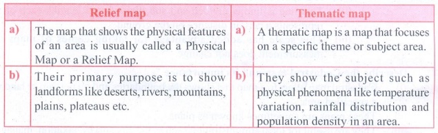
Relief
map
a) The map that shows the physical features of an area is
usually called a Physical Map or a Relief Map.
b) Their primary purpose is to show landforms like deserts,
rivers, mountains, plains, plateaus etc.
Thematic
map
a) A thematic map is a map that focuses on a specific theme or subject
area.
b) They show the subject such as physical phenomena like
temperature variation, rainfall distribution and population density in an area.
2. Large scale map and small scale map.
Answer:
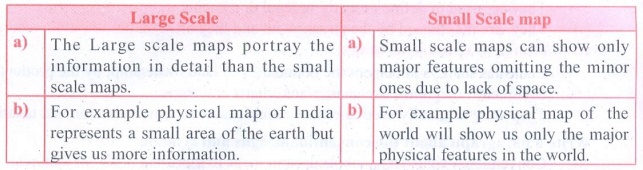
Large
Scale
a) The Large scale maps portray the information in detail than
the small scale maps.
b) For example physical map of India represents a small area of
the earth but gives us more information.
Small
Scale map
a) Small scale maps can show only major features omitting the
minor ones due to lack of space.
b) For example physical map of the world will show us only the
major physical features in the world.
3. Globe and Map.
Answer:
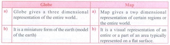
Globe
a) Globe gives a three dimensional representation of the entire
world..
b) It is a miniature form of the earth (model of the earth)
Map
a) Map gives a two dimensional representation of certain regions
or the entire world.
b) It is a visual representation of an entire or a part of an
area typically represented on a flat surface.
VII Answer in a
paragraph
1. Explain the different types of scales in detail.
Answer: Scales on maps can be represented in three different ways. They
are:
(a) Statement or Verbal scale
(h) Representative Fraction (RF) or Ratio Scale
(c) Graphical or Bar Scale
(a) Statement
or Verbal scale:
(i) In this method, the map scale is stated in words i.e., 1cm
to 1 km.
(ii) It means 1cm distance on the map corresponds to 1 km
distance on the ground.
(iii) Thus it is written on the map like 1cm to 1 km.
b)
Representative Fraction (RF) or Numerical Fraction or Ratio Scale:
(i) It shows the relationship between the map distance and the
corresponding ground distance in the same units of length.
(ii) R.F. is generally shown as a fraction.
(c)
Graphical or Bar Scale or Linear Scale:
(i) A graphic scale looks like a small ruler drawn at the bottom
of the page.
(ii) This line is line is divided and sub divided into lengths
each of which represents a certain distance on the ground.
(iii) This scale has added advantage for taking copies of maps
as the measurement does not change.
2. Describe the Cadastral map and its importance.
Answer:
(i) Cadastral map refers to a map that shows the boundaries and
ownership of land within a specified area. ,
(ii) These maps are sometimes known as plans.
(iii) They are useful for local administration such as the city
survey, taxation, management of estates.
(iv) They are used to define property in legal documents
(v) They are maintained by the government and they are a matter
of public record.
Importance of Cadastral maps:
(i) Cadastral surveys document the boundaries of land ownership,
by the production of documents, diagrams, sketches, plans, charts and maps.
(ii) They were originally used to ensure reliable facts for land
valuation and taxation.
3. Write a paragraph about the conventional signs and
symbols.
Answer:
(i) Conventional signs are symbols used in maps to represent
different features.
(ii) The symbols are explained in the key of the map.
(iii) These symbols give a lot information in a limited space.
(iv) With the use of these symbols, maps can be drawn easily and
the concept of the map can be understood well. There is an International
agreement regarding the use of certain symbols.
(v) The symbols fall under this category are Called Conventional
Symbols. Other category is called contextual symbols which are decided by the
cartographers
VIII Students Activity
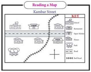
a. Underline the map title
b. Show the direction of N,S,W & E on the map.
c. The rail track runs from Southwest to________.
d. In which direction of the rail track, the park is
located?
e ) Colour the school with red.
f. Colour the supermarket with brown.
g. Colour the restaurant with yellow.
h. Colour the house east of the railroad with orange.
Related Topics