Atmosphere | Geography | Social Science - Paragraph Questions | 9th Social Science : Geography : Atmosphere
Chapter: 9th Social Science : Geography : Atmosphere
Paragraph Questions
ATMOSPHERE
VI. Paragraph
Questions
1. Write a paragraph about the
structure of the atmosphere.
Structure of the
Atmosphere :
• The Atmosphere has 5 layers Troposphere, Stratosphere,
Mesosphere, Thermosphere, Exosphere.
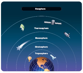
Troposphere (Height
: 8 km at the poles; 18 km at the Equator)
• The temperature decreases with increasing height. Almost all
weather phenomenon take place here.
• It is called weather making layer. (upper limit - tropopause)
Stratosphere:
(Height: 18 km - 50 km)
• This is a concentration of ozone molecules. It is also
referred as ozonosphere. The temperature increases with increasing height.
Large set planes normally fly here. (upper limit - stratopause)
Mesosphere:
(Height: 50 km - 80 km)
• The temperature increases with increases with increasing
height. It helps for Radio waves transmission.
Most of the meteors nearing the earth, get burned (upper limit -
mesopause)
Thermosphere:
(Height 80 km - 600 km)
• The composition of gases in the lower portion (Homosphere) is
uniform. The composition of gases in the upper portion (Heterosphere) is
uneven. The temperature increases with increasing height Ionosphere contains
Ions and free electrons.
Exosphere: (Beyond
broken)
• The uppermost layer of the atmosphere. This is extremely
rarefied with gases and gradually merges with the outer space.
2. Explain the different types of
permanent winds.
The horizontal movement of air along the surface of the earth is
called the 'wind'
• Planetary winds
• Periodic winds
• Variable wind
• Local wind are the four major types of winds.
Planetary winds:
• The winds which constantly blow in the same direction
throughout the year. They are called 'the prevailing winds'. Trade winds,
westerlies and polar easterlies are planetary winds.
• The winds that are very helpful to traders sailing in the sees
are called 'Trade wind'
• The winds that blow from south west to North East in the
northern hemisphere and North West to South East in the Southern hemisphere are
‘Westerlies'
• The winds that blow from North East direction in the Northern
Hemisphere and South East direction in the Southern Hemisphere are 'Polar Easterlies'
Periodic winds:
• Because of the differential heating of land and Ocean the
seasonal winds that change their direction. Periodically. These are called 'monsoons'.
Ex. South West monsoon, North East monsoon.
Variable winds:
• The disturbance and the changes in the local weather cause
variations in the prevailing winds. Variable
winds end up with the development of cyclones, anticyclones and storms.
• The winds from the surrounding high pressure area converge
towards the centres of low pressure in a spiral form are 'cyclones'.
Local winds:
• The winds that blow only in a particular locality for a short
period of time are 'Local winds'.
3. How are clouds classified?
Explain them.
High Clouds (Height
6-20 km)
• Cirrus (8000 meters -12000 meters) These are dry; donot give
rainfall, (white filaments).
• Cirro-cumulus - composed of ice crystals (White patched sheet)
• Cirro - stratus - Smooth milky transparent whitish. Composed
of tiny ice crystals.
Middle clouds
(Height 2.5 - 6 km)
• Alto - Stratus - thin sheets of grey or blue coloured.
Consisting of frozen water droplets.
• Alto - cumulus - fitted closely together in parallel bands.
They are cloud 'Sheep clouds' or 'wool pack' clouds.
• Nimbo stratus - dark colour very close to the ground surface.
Associated with rain, snow or sleet.
Low clouds (Height
- Ground surface - 25 km)
• Strato-cumulus (2500 meters - 3000 meters) Grey or whitish
layer low clouds in rounded patches. Associated with fair or clear weather.
• Stratus - Dense, low lying fog-like clouds. Associated with
rain or snow.
• Cumulus - Flat base, dome-shaped, often resembling a
cauliflower. Associated with fair weather.
• Cumulo-nimbus - Fluffy thick towering thunderstorm cloud,
(capable of producing heavy rain, snow, hailstorm or tornadoes)
4. How are cyclones formed? How
are they classified?
Cyclones are centres of low pressure where, winds from the
surrounding high pressure area converge towards the centres in a spiral form.
Classifications:
• Tropical cyclones
• Temperate cyclone
• Extra tropical cyclones
Tropical cyclones:
• Due to the differential heating of land and sea, in the inter
tropical convergence zone, formed the 'Tropical Cyclones'. They cause heavy
loss of life and property.
Temperate cyclones:
• Between 35° and 65° N and S latitudes, the front where hot and
cold air masses meet, the temperate cyclones are formed. They do not become
weak on reaching the land on the tropical cyclones.
• Commonly occurs over the north Atlantic ocean, North west
Europe. Mediterranean basins. Mediterranean temperate cyclones extend up to
Russia and India. In India it is called 'western disturbances'.
Extra tropical
cyclones
• Between 30° and 60° latitudes in the both the hemispheres,
occur "Extra trophical Cyclones". They collect energy from
temperature differences in higher latitudes. Also called "mid latitude cyclones".
• They produce mild showers to heavy gales, thunderstorms,
blizzards, and tornadoes.
5. Explain the different forms of
precipitation.
Falling down of condensed water vapour in different forms is
called Precipitation. Drizzle, rain, sleet, snow, hail are the main forms of
precipitation.
• Drizzle : Falling
of numerous uniform droplets of water with diameter of 0.5 mm is called a
'Drizzle'.
• Rain : In places
having temperature above the freezing point falls 'Rain'. It is the important
form of precipitation occurs only. Where there is abundant moisture in the air.
(The diameter of a rain drop is more then 5 mm.)
• Sleet: Sleet is in
the form of pellets made up of transparent and translucent ice.
• Snow : When
condensation occours below freezing point snow
is formed. It is the precipitation of opaque and semi opaque ice crystals.
• Hail: Chunks of ice
falling from the sky during a rainstorm are Hails, (chunk of ice - greater then
2 cm in diameter)
VII. Activity (For
Students)
1. Preparing chart of clouds
at various atmospheric layers.
2.
Collecting Proverbs clouds and rain
related Proverbs
3.
Poem on 'clouds', 'rain'
4.
Report writing observe the clouds
for a week, Write your report about the shape and colours of clouds.
5.
Working models a) Rain Gauge b) Wind
vane
6.
Preparing bar diagram
a.
Collect the data of temperature of
Kanyakumari, Delhi, Allahabad, and Itanagar for a day. Also collect the data of
rainfall received by Jaisalmer
(Rajasthan), Mawsynram (Meghalaya), Nagapattinam, Coimbatore for a day.
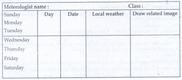
7.
Become a budding Meterologist: Record
the local weather condition of your place for a week.
Related Topics