Map Reading | Term 3 Unit 2 | Geography | 7th Social Science - Exercises Questions with Answers | 7th Social Science : Geography : Term 3 Unit 2 : Map Reading
Chapter: 7th Social Science : Geography : Term 3 Unit 2 : Map Reading
Exercises Questions with Answers
Evaluation
I. Choose
the correct Answer:
1. The science of map making
is called _______________.
a.
Geography
b.
Cartography
c.
Physiography
d.
Physical Geography
[Answer : (b)
Cartography]
2. North, South, East
and West are four directions are called as
a.
Cardinal
b.
Geographical
c.
Latitudinal
d
Angels
[Answer : (a)
Cardinal]
3. Cultural maps are
those which shows the _____________ features
a.
Natural
b.
Man-made
c.
Artificial
d.
Environmental
[Answer : (b)
Man-made]
II. Fill
in the blanks:
1.
Map
is an essential tool of a geographer.
2.
The directions in between the cardinal directions are the inter mediate directions.
3.
Legend
in a map which explains the different colours and symbols used in it.
4.
Cadastral maps are known as Village and town
maps.
5.
Small scale maps are helpful to us to show large areas like continents
and countries.
III. Circle
the odd one:
1.
North East, Scale. North West and East.
Answer: North East,(Scale),North
West and East.
2.
White, Snow, High land, and Plains.
Answer: White, Snow, High land, and (Plains)
3.
Relief map, Soil map, Physical map and Atlas.
Answer: Relief map, Soil map, Physical map and (Atlas)
4.
Weather Forecasting, Climate, Rainfall and Temperature.
Answer: Weather Forecasting, (Climate),
Rainfall and Temperature.
IV. Match
the following:
1.
Upper right corner – Density and growth
2.
Key (or) legend – District (or) town
3.
Large Scale map – Natural relief features
4.
Physical map – Colours and Symbols
5.
Population map – ‘N’ letter
Answer:
1. Upper right
corner - ‘N’ letter
2. Key (or)
legend - Colours and Symbols
3. Large Scale
map - District (or) town
4. Physical
map - Natural relief features
5. Population
map - Density and growth
V. Examine
the Following Statements:
1.
An Atlas is a bound volume of different types of maps
2.
Atlas maps are drawn on smaller scale
3.
Insignificant details are omitted
a.
1 and 3 are correct
b.
2 and 3 are correct
c.
1 and 2 are correct
d.
1, 2 and 3 are correct
[Answer : (d) 1, 2
and 3 are correct]
2.
Statement I: Globe is a three
dimensional model of the Earth.
Statement II:
It is easy to handle and to carry. as it can be rolled up or folded.
a.
Statement I is correct and II is wrong.
b.
Statement I is wrong and II is correct.
c.
Both the statements are correct.
d.
Both the statements are wrong.
[Answer : (a)
Statement I is correct and II is wrong]
VI. Name
the following:
1.
Representing the earth on a flat surface. Answer: Map
2.
Ratio between the distance on a map and distance on the ground. Answer: Scale
3. Symbols which help to show road ways and railways.
Answer: Road ways -  , Railways -
 | || || || || || |
4.
A book which contains different kinds of maps.
Answer: Atlas
5.
A map which shows administration divisions.
Answer: Political map
VII. Answer
the following:
1. What is a map?
Answer: (i) A map is
an essential tool of a geographer.
(ii) Map is a representation of the earth as a whole or a part of the
earth drawn on a flat surface according to a given scale.
(iii) It can show continents, countries, cities and even a local area
are drawn with specific details.
2. What is cartography?
Answer: The science of map-making is called cartography (carte means
‘map’ and graphic means ‘drawing’). One who draws maps is called a
Cartographer.
3. What are cardinal
directions?
Answer: (i) The cardinal direction are North, South, East and West.
(ii) A legend (or) key of a map explain the details in the map.
4. What is an Atlas?
Answer:
(i) Atlas is a collection of maps in a book.
(ii) Atlas maps are small-scale maps covering large areas like
continents and countries.
(iii) Only prominent relief features, main roads and railways
important towns are shown in Atlas maps.
(iv) The study of geographic characteristics of a large area is
possible at the time with the help of an atlas.
5. Name the types of
Atlas?
Answer:
(i) School Atlas
(ii) Advanced Atlas
(iii) Regional Atlas
(iv) National Atlas
6. What are the uses of
maps?
Answer: Uses of
Maps:
(i) Maps enable us to know details of the landforms and other
ground features without seeing the area.
(ii) Maps are of immense importance to the military personnel for
planning campaigns.
(iii) It is used in the aero planes to reach their destinations and
the ships to sail safely in the oceans.
(iv) Maps are used for weather forecasting and agricultural
operations.
(v) We can study and interpret the future possibilities of soil
erosion, settlement patterns, drainage patterns, land utilization, etc.,
VIII. Answer
in Detail:
1. What are the
elements of maps? Write about it?
Answer: Elements of
maps:
(i) Maps provide us with a lot of information and one must know how
to read and interpret them.
(ii) Every map is provided with certain features that act as an aid
to study the information presented in it.
(iii) The basic essential elements of a map are title, direction,
scale and legend (or) key of symbol.
Title:
Every map has a title that describes the information given in
the map. For example, a map with the title India Rivers shows Rivers of India.
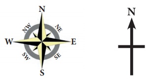
Direction:
(i) In general maps are drawn with north orientation it helps us to
find other direction on the map like East, West and South. In addition to the
North notation, latitudes and longitudes were depicted in the margins.
(ii) The North is notified by letter ‘N’ with an arrow mark.
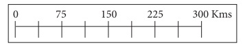
Scale :
(i) The scale of a map is the ratio between the distance on the map
between two points and actual distance between the two places on the ground.
(ii) The scales can be represented as lcm = 10km.
(iii) It means lcm on the map is equal to 10 km on the ground. It
helps to find the distance on the map between two points.
Legend:
(i) A legend or key of a map explain the symbols that are used on
it to represent various physical and cultural features.
(ii) The common signs and symbols are internationally accepted and
used in maps are called conventional signs and symbols.
(iii) Every map has a legend or a key which explains the different
colours and symbols used in it.
(iv) They are depicted by using certain colours, symbols or letters.
2. What are the three
ways of representation of maps?
Answer: Maps are a graphical representation of the world or a section of
the world. As a representation of the world, maps are compressed versions of
the real world meaning that a large piece of land is recreated onto a smaller
piece of paper or digital file. The relationship between the real world size of
a geographic feature and its representative feature on a map is known as scale.
There are three main ways that scale is indicated on a map: graphic (or bar),
Verbal and representative fraction (RF).
3. Classify the maps
based on functions
Answer: (i) Physical maps show
natural features such as relief, geology, soils, drainage, elements weather,
and vegetation.
(ii) Relief Maps show general topography like mountains valleys, plains,
plateaus and rivers.
(iii) Geological
Maps are drawn to show geological structures, rocks and minerals.
(iv) Climatic Maps show the distribution of temperature, rainfall,
clouds, relative humidity, direction and velocity of winds and other elements
of weather.
(v) Soil Maps which are drawn to show the distribution of different types of
soil and their properties.
(vi) Cultural Maps which shows the man-made features are called cultural maps.
(vii) Political
Maps show the administrative divisions of a country, state or
district. These maps facilitate the administration in planning and management
of the concerned administrative units.
(viii) Population
Maps show the distribution, density and growth of population,
occupation structure and literacy.
(ix) Economic Maps depict the production and distribution of different types of
crops and minerals, location of industries, trade routes and flow of
commodities.
(x) Transportation Maps
show roads, railway lines and the location of railway station, airports and
seaports, etc.,
(xi) Thematic maps are
all such maps that represent the distribution of a particular feature or theme
and its spatial variation.
(xii) Google maps is a
web-based service that provides detailed information about geographical regions
and sites around the world.
4. Write about
comparison of map and Globe
Answer:
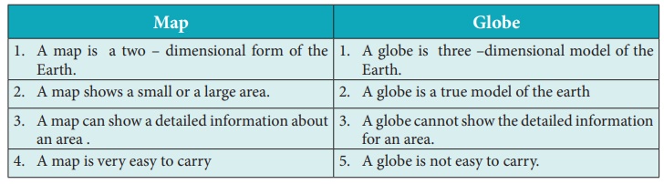
Map
1. A map is a two - dimensional form of the Earth.
2. A map shows a small or a large area.
3. A map can show a detailed information about an area .
4. A map cannot be turned
to explain rotation.
5. A map is very easy to carry
Globe
1. A globe is three -dimensional model of the Earth.
2. A globe is a true model of the earth.
3. A globe cannot show the detailed information for an area.
4. A globe can be turned to show rotation.
5. A globe is not easy to carry.
5. Describe the types
of maps based on the scale? Write about it?
Answer:
Maps on the basis
of scale:
(i) Large scale
maps show small areas in greater details because they are drawn on a
relatively large scale.
(ii) Cadastral maps are village and town maps which show individual fields and
house sites.
(iii) Topographical
Maps shows smaller areas in much greater detail. These maps are
prepared by Survey of India. These are also large scale maps which show both
natural features like hills and valleys as well as man-made features like
buildings, road and canals.
(iv) Small scale
maps that show large areas like continent or countries. These maps
are drawn on 1cm = 1000 kms. These are called small-scale maps.
(v) Wall maps are small-scale maps showing large areas. They are useful for
students in classrooms and offices, small scale maps covers a larger area and
depicts with limited information.
(iv) Atlas is a collection of maps in a book. Atlas maps are small-scale
maps covering large areas like continents and countries. Only prominent relief
features, main roads and railways important towns are shown in Atlas maps. The
study of geographic characteristics of a large area is possible at the time
with the help of an atlas.
IX. HOTs
1. Map is an essential
tool for a traveller why?
Answer: Map is an essential tool for a traveller, It helps a traveller
to find out direction. It also tells about the latitudinal and longitudinal
extent of a place. It helps one to locate a place easily and follow the correct
travelling route.
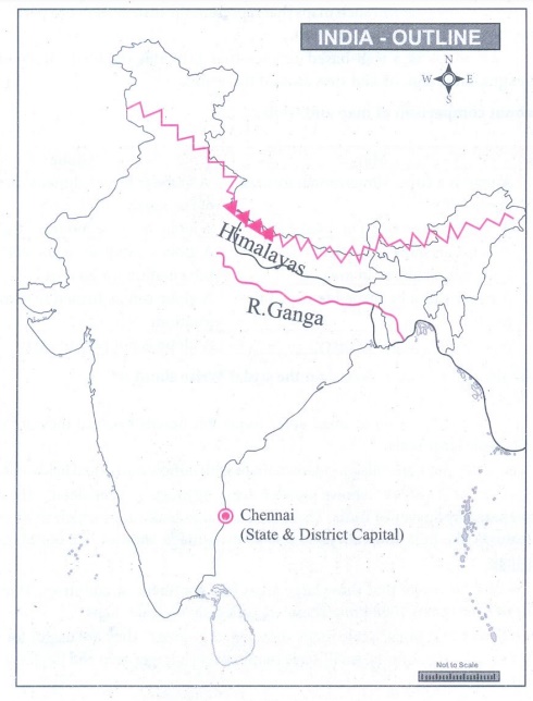
X. Activity:
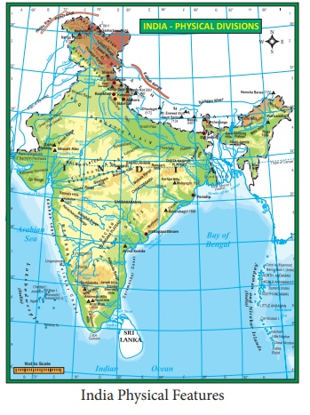
1.
In an outline map of India mark the following features by using symbols and
colours
a.
Mark any one of the District capitals
b.
Draw any one river path
c.
Mark any one of the mountains
Answer:
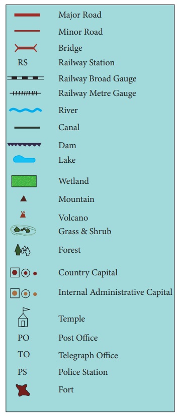
2.
Draw the convectional signs and symbols to given points
a.
Bridge
b.
Canal
c.
Dam
d.
Temple
e.
Forest
f.
Railway Station
Answer:
Related Topics