Exploring Continents -North America and South America | Term 3 Unit 1 | Geography | 7th Social Science - Exercises Questions with Answers | 7th Social Science : Geography : Term 3 Unit 1 : Exploring Continents -North America and South America
Chapter: 7th Social Science : Geography : Term 3 Unit 1 : Exploring Continents -North America and South America
Exercises Questions with Answers
Evaluation
I. Choose
the correct answer
1. The -----------------
separates North America from Asia
a.
Bering Strait
b.
Palk Strait
c.
Malacca Strait
d.
Gibraltar straits
[Answer : (a)
Bering Strait]
2. ------------- is
known as the “sugar bowl of the world”
a.
Mexico
b.
USA
c.
Canada
d.
Cuba
[Answer: (d) Cuba]
3. ----------------- are
the longest rivers in North America
a.
The Mississippi and Missouri rivers
b.
The Mackenzieriver
c.
The St. Lawrence river
d.
The Colorado river
[Answer : (a) The
Mississippi and Missouri rivers]
4. -------------- is
the longest mountain chainin the world.
a.
The Andes
b.
The Rockies
c.
The Himalayas
d.
The Alps
[Answer : (a) The
Andes]
5. ---------------- basin
gets rainfall every day because of its equatorial location
a.
The Mackenzie
b.
The Orinoco
c.
The Amazon
d.
The Paraná
[Answer: (c) The
Amazon]
II. Fill
in the blanks
1.
Death valley is
86m below the sea level is the lowest part of the continent of North America.
2.
Grand Bank
is one of the world's best fishing grounds.
3.
The highest peak in the Andes is Mt Aconcagua on the Chile -
Argentina border.
4.
The Selvas
of the equatorial regions are called the “lungs of the world”.
5.
Brazil
is also known as the “coffee pot” of the world.
III. Match
the following
1.
Mount McKinley – Tropical forests
2.
Grand Canyon – The flightless bird
3.
Ebony – The ColoradoRiver
4.
4’o Clock Rains – 6194 m
5.
Rhea – The equatorial regions
Answer:
1. Mount McKinley -
6194 m
2. Grand
Canyon - The Colorado River
3. Ebony - The equatorial regions
4. 4’o Clock
Rains - Tropical forests
5. Rhea - The flightless bird
IV. Give
Reasons
1. The eastern coast of
North America particularly USA enjoys mild climate.
Answer: The South and east is usually warm all the year round and the
regions around the mouth of the Mississippi-Missouri and the Gulf Coast have
summer rain from the North East Trades which blow on-shore in summer.
2. United States of
America is known as “Melting Pot”.
Answer: United States of America
is known as “Melting Pot” where hundreds of different cultures meet, blend and
creating a new culture.
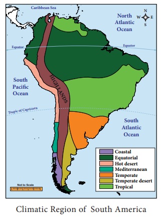
3. Though Quito and
Amazon basin are in the same latitude Quito enjoys eternal Spring. Whereas
Amazon basin is hot.
Answer:
(i) The climate of the continent of South America has been closely
influenced by the latitudes, attitudes and the proximity of the Pacific and
Atlantic Oceans.
(ii) It is hot in the Amazon basin as the equator passes through it
whereas Quito, situated almost on the same latitude on the Andes, has “Eternal
Spring”.
(iii) That is, it has a pleasant climate throughout the year because
of its high attitude at 9,350 feet or 2849.88 meter above the sea level.
4. Peru is one of the
world’s largest producers of tropical fish.
Answer:
(i) Peru is one of the worlds largest producers of tropical fish.
Here the cool Humboldt Current helps in bring plankton, which is the main food
for fishes.
(ii) Commercial deep sea fishing off of Peru’s coastal belt of over
3000 km.
(iii) Peruvian waters normally abound with sword fish, mackerel,
yellow fin, pompano and shark.
(iv) More than 50 species are caught commercially.
(v) There are over 40 fishing ports on the Peruvian coast.
(vi) Paita and Callao are being the most important centers in Peru.
V. Distinguish
between
1. The Rocky mountain
and the Appalachian mountain.
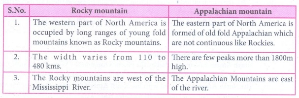
Answer:
Rocky mountain
1. The western part of North America is occupied by long ranges
of young fold mountains known as Rocky mountains.
2. The width varies from 110 to 480 kms.
3. The Rocky mountains are west of the Mississippi River.
Appalachian
mountain
1. The eastern part
of North America is formed of old fold Appalachian which are not continuous
like Rockies.
2. There are few peaks more than 1800m high.
3. The Appalachian Mountains are east of the river.
2. The Prairies and the
Pampas grassland.
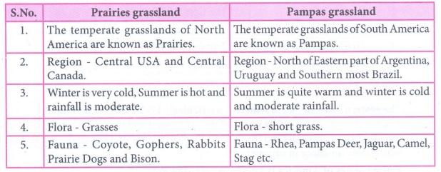
Prairies grassland
1. The temperate grasslands of North America are known as
Prairies.
2. Region - Central USA and Central Canada.
3. Winter is very cold, Summer is hot and rainfall is moderate.
4. Flora - Grasses
5. Fauna - Coyote, Gophers, Rabbits Prairie Dogs and Bison.
Pampas grassland
1. The temperate
grasslands of South America are known as Pampas.
2. Region - North of Eastern part of Argentina, Uruguay and
Southern most Brazil.
3. Summer is quite warm and winter is cold and moderate
rainfall.
4. Flora - short grass.
5. Fauna - Rhea, Pampas Deer, Jaguar, Camel, Stag etc.
3. Tundra and Taiga.
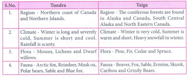
Answer:
Tundra
1. Region - Northern coast of Canada and Northern Islands.
2. Climate - Winter is long and severely cold, Summer is short
and cool. Rainfall is scanty.
3. Flora - Mosses, Lichens and Dwarf willows.
4. Fauna - Arctic fox, Reindeer, Musk ox, Polar bears, Sable and
Blue fox.
Taiga
1. Region - The coniferous forests are found in Alaska and North
Eastern Canada.
2. Climate - Winter is very cold, Summer is warm and short.
Heavy snowfall in winter.
3. Flora - Pine, Fir, Cedar and Spruce.
4. Fauna - Beaver, Fox, Sable, Ermine, Skunk, Caribou and
Grizzly Bears.
VI. Put
(√) for the correct option
1.
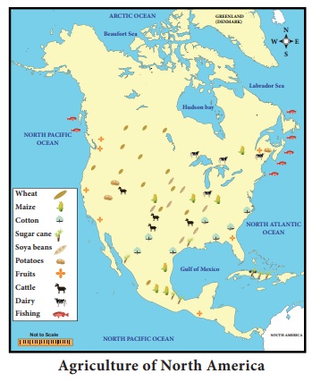
Assertion (A): Cotton grows well in
southern and western states of North America.
Reason (R):
Warm summer with frequent rainfall and fertile soil which provide favourable
condition.
a.
Both A and R is correct.
b.
A is correct and R is wrong.
c.
A is wrong and R is correct.
d.
Both A and R is wrong
[Answer : (a) Both
A and R is correct]
2. Assertion (A): Industries in the
South America has developed rapidly.
Reason (R):
The continent lacks infrastructure (especially transport) need for
industrialization.
a.
Both A and R are correct.
b.
A is correct and R is wrong.
c.
A is wrong and R is correct.
d.
Both A and R are wrong
[Answer : (c) A is
wrong and R is correct]
VII. Answer
the following
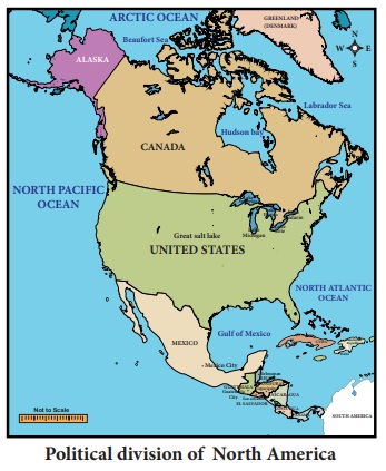
1. Name the boundaries
of North America.
Answer:
(i) North America is surrounded by the Pacific Ocean in the West,
the Atlantic Ocean in the east, Arctic Ocean in the north and South America in
the south.
(ii) The North America is joined with the South America by the
Isthmus of Panama.
(iii) The Bering Strait separates North America from Asia.
2. Write a note on
Mackenzie River.
Answer: The Mackenzie River is the second largest drainage basin of
North America. It has it source from Great Slave Lake and drains into Arctic
Ocean.
3. What type of fruits
are cultivated in North America? Name some of them.
Answer:
(i) Mainly Citrus Fruits are cultivated in Texas, California, Great
Lakes regions and St. Lawrence Valley.
(ii) The important Fruits of North America are Cranberries,
Blueberries, Concord Grapes, Strawberries, Gooseberries and the other fruits.
4. Give a short note
about the lifestyle of an Eskimos.
Answer:
(i) Eskimos live in the very cold and inhospitable region where
plenty of fish varieties are available.
(ii) They were able to dress themselves in thick warm clothes made
of fur, they live in igloos.
(iii) Their lives were very simple and they could not alter the
environment to any extent.
(iv) They specially designed a house by ice and is known as igloos.
5. Which are the
densely populated areas of North America?
Answer:
Densely populated
areas: Eastern part of North America, Great Lakes
region, Florida, California, Mexico and Central America are the mostly densely
populated areas.
6. Name the
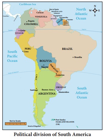
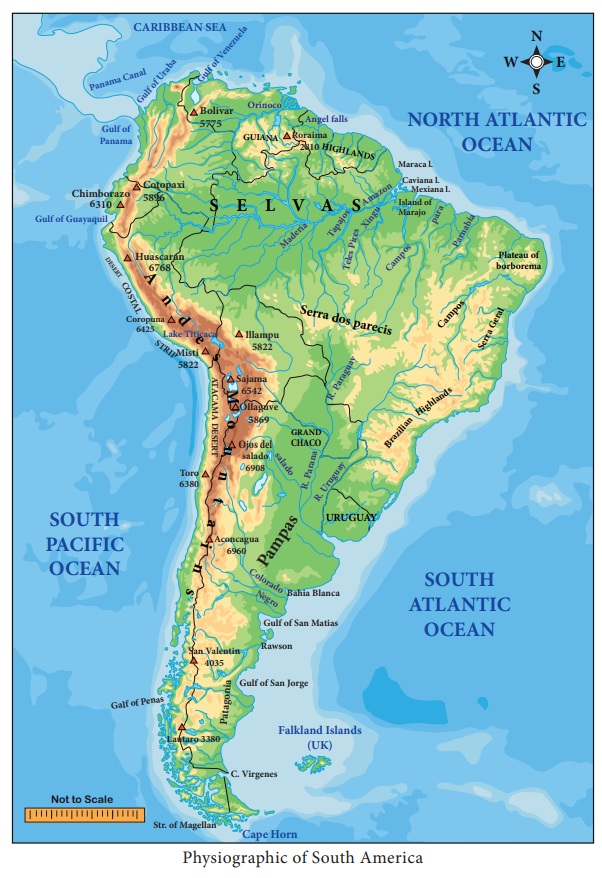
physiographic divisions of South America.
Answer:
On the basis of topographical features, the continent may be
divided into the following physiographic divisions:
(i) The Andes Mountains
(ii) The River Basin or Central Plains
(iii) The Eastern Highlands
7. What is called “4’o
clock rains”?
Answer:
In equatorial regions convectional rain occurs almost daily in
the afternoons. It generally occurs at 4pm that’s why it is known as 4’ o Clock
Rain.
8. Name the flora and
fauna of equatorial forest in South America.
Answer:
(i) Flora: Rubber, Mahogany, Ebony, Logwood, Brazil nuts and Ceiba.
(ii) Fauna: Anaconda, Armadillo, Piranha, Monkey, Snake, Crocodile and
Parrots.
9. What is known as
“Estancias”?
Answer:
The Breeds raised on large pasture lands is known as Estancias.
These are divided into several paddocks. Besides this, there are small yards
known as corrals where animals are sorted and branded. The owner is the
Estanciera who has a number of gauchos.
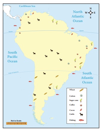
10. Name the major
export of South America.
Answer:
South Americas major exports are mostly primary commodities such
as sugar, coffee, cocoa, tobacco, beef, corn, wheat, petroleum, natural gas,
linseed, cotton, iron ore, tin and copper. South Americas products include
mostly exported to North America and Europe.
VIII. Answer
the following in a paragraph
1.
Give an account of the climate of North America.
Answer:
(i) The vast latitudinal extent from the Tropics to the Polar
Regions makes the climate of North America as varied as that of Asia.
(ii) Unlike the Himalayas, the Rockies run north to south which do
not form climatic barrier and do not prevent the icy winds from the Arctic
region and penetrating the central plains which therefore have a very long cold
winter and very short hot summer.
(iii) Precipitation occurs due to cyclonic storms.
(iv) The Arctic region is cold and mostly dry and has a very short
summers and a very long bitterly cold winter.
(v) As one proceeds southwards the short summers become warm but
the winters are very cold.
(vi) The central plains have extreme climate from freezing
conditions in winter to tropical heat in summer.
(vii) The South is usually warm all the year round and the regions
around the mouth of the Mississippi-Missouri and the Gulf Coast have summer
rain from the North East Trades which blow on-shore in summer.
(viii) The warm moist South Westerlies not only bring rainfall to the
North West coast and also keep it warm.
(ix) The warm Alaskan Current keeps the North.West coast ice free.
(x) The State of California in USA has a Mediterranean Climate with
moist winter and dry summers.
2. Describe the Heavy
Engineering Industries in North America.
Answer: Heavy
Engineering Industries:
(i) Industries which require heavy and bulky raw materials using
enormous amounts of power, involvement of huge investment and large transport
costs are called heavy industries.
(ii) These industries depend heavily on the Iron and Steel industry.
(iii) The important Heavy Industries are automobile industries,
aircraft industries, ship building industries, Railway Wagon industries and
farm equipment industries.
(iv) USA is the largest producer of automobiles.
(v) The important Centers of heavy engineering industries are
Detroit, Chicago, Buffalo, Indianapolis, Los Angeles, Saint Louis,
Philadelphia, New York, Baltimore, and Atlanta in USA and Windsor in Canada.
3. Describe the
drainage system in South America.
Answer: (i) Owing to the position of the Andes all the great rivers of the
continent drain into the Atlantic.
(ii) The Pacific streams are short and swift but along the coastlands
of Peru their waters are used for irrigation and to some extent for
hydro-electric power. Amazon is the longest river of South America (6,450km)
and is the largest river system in the world.
(iii) This river has over a thousand of tributaries.
(iv) The rivers Rio Negro, Madeira and Tapajos are important
tributaries.
(v) At the point where it enters the sea the river is so wide and
powerful that it flows even at a distance of 80 km into the high seas.
(vi) The Orinoco River originates in the Guiana Highlands and flows
northwards into the Caribbean Sea.
(vii) The river Paraguay has the Parana and Uruguay rivers as the
main tributaries which together form and known as the Platte River system.
(viii) All the rivers are navigable for quite some distance in the
interior.
4. Write briefly about
the major races in South America.
Answer:
(i) South America
contains the world’s most mixed population.
(ii) Many people in South America are descended from European,
especially the Spanish and Portuguese, who begin to arrive during the 15th
century.
(iii) The descendants of African slaves brought over by the
Europeans. Native people still live in the mountain and the rainforests and
keeping their own languages and traditions.
(iv) There are three major races found in South America and are (i)
American Indian, (ii) European and (iii) Blacks. The mixed population of Native
Indians and Europeans is known as ‘Mestizo’.
(v) The mixed population of European and the Blacks is called
‘Mulato’ and the mixture of Native Indians and Blacks is called ‘Zambo’.
(vi) The current population of South America is 429, 115, 060 (42.25
cores). Population density of South America is 21 persons per square kilometer.
(vii) South America is positioned 5th rank in total
population among the continents.
IX. Map
skill
1. With the help of the
map given in the text and an atlas, name the seas and bays in North America.
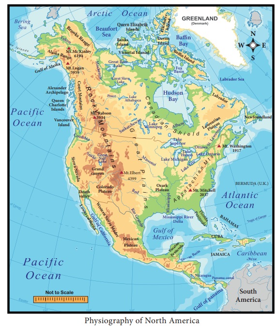
2. Mark the rivers
Amazon, Orinoco, Negro, Paraguay, Uruguay on a map of South America.
X. Activity
1. Given below are some
important cities with industries placed in brackets. Pick out the correct
answer from them.
a. Pittsburgh (Textile,
Iron and steel, Shipping) [Answer : Iron and steel]
b. Chicago (Meat
Packing, Woolen textile, Heavy Engineering) [Answer : Meat Packing]
c. Ontario (Automobile,
Paper, Cement) [Answer : Paper]
d. Chile (Oil refinery,
Sugar, Cotton textile) [Answer : Oil refinery]
e. Uruguay (Leather
processing, Copper smelting, Daily products) [Answer : Dairy products]
2. Write down the
answers to the question given in blocks:
a. Name the highest peak in South America.
A C O N C A G U A
b. An active volcano in South America.
C O T O P A X I
c. The combined Parana and Paraguay rives.
P L A T T E
d. The highest falls in the world.
A N G E L
e. The largest river in the world.
A M A Z O N
3. Collect pictures of
the animals and birds of North America and South America and make a scrap book.
Related Topics