Mapping Skills | Geography | Social Science - Distinguish Between the Following | 9th Social Science : Geography: Mapping Skills
Chapter: 9th Social Science : Geography: Mapping Skills
Distinguish Between the Following
MAPPING SKILLS
VI. Distinguish
Between the Following
1. Globe and Map
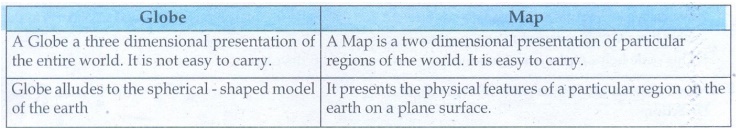
Globe
• A Globe a three dimensional presentation of the entire world.
It is not easy to carry.
• Globe alludes to the spherical - shaped model of the earth
Map
• A Map is a two dimensional presentation of particular regions
of the world. It is easy to carry.
• It presents the physical features of a particular region on
the earth on a plane surface.
2. Aerial photographs and satellite imageries
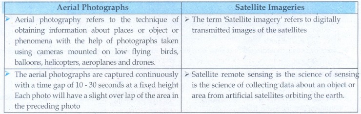
Aerial Photographs
• Aerial photography refers to the technique of obtaining
information about places or object or phenomena with the help of photographs
taken using cameras mounted on low flying birds, balloons, helicopters,
aeroplanes and drones.
• The aerial photographs are captured continuously with a time
gap of 10 - 30 seconds at a fixed height Each photo will have a slight over lap
of the area in the preceding photo
Satellite Imageries
• The term 'Satellite imagery’ refers to digitally transmitted
images of the satellites
• Satellite remote sensing is the science of sensing is the
science of collecting data about an object or area from artificial satellites
orbiting the earth.
3. GIS and GPS
![]()
GIS
• Geographic Information system is a computer - based tool for
managing a large amount of data collected for a given geographic region through
remote sensing. GPS and other sources.
•The geographic information system is a combination of computer
hardware, software, geographic data, and the personal.
GPS
• Global position system technology has tremendous applications
in every - thing from mobile phones, watches, bulldozers, shipping containers
and ATMs.
• The main purpose of GPS is to help in providing accurate
transport data. It helps in military searches and rescue in wars. It can work
as a reliable tourist guide.
Related Topics